
the roads and trails and whats open aint on ur iphone. and gps tells u where u at and where ya been, not where ur going. ill trust a magnet over anything apple makes. :) they are handy for overall direction. but what angle, direction, and rise of any road tells u where u are at. this is rainforest full of loggers. what looked likes one day sometime its just gone the next. intersections of roads and creeks, counting creeks, are both landmarks. odd old cotton woods make nice markers too. mile markets are dam handy too. tropical maps that u can mark on an iphone would be cool. do not trust or waste ur time down new roads. they only lead to construction or logging and r usually the hardest on ur vehicle. and end up going nowhere. i drive a stock 4x4. it is a jeep type unit. tracker. the roads were all made when they had too many of the old army 4 seater jeeps. trackers are reallly a copy. the forest rangers all had army jeeps and they made the original trails into every corner. now logging has. but u can tell a forestry rd from a logging road and the two types of old n newer style train tracks. i guess in a few places like extension the old horse cart, earliest of roads, can stil be followed.
freebee!
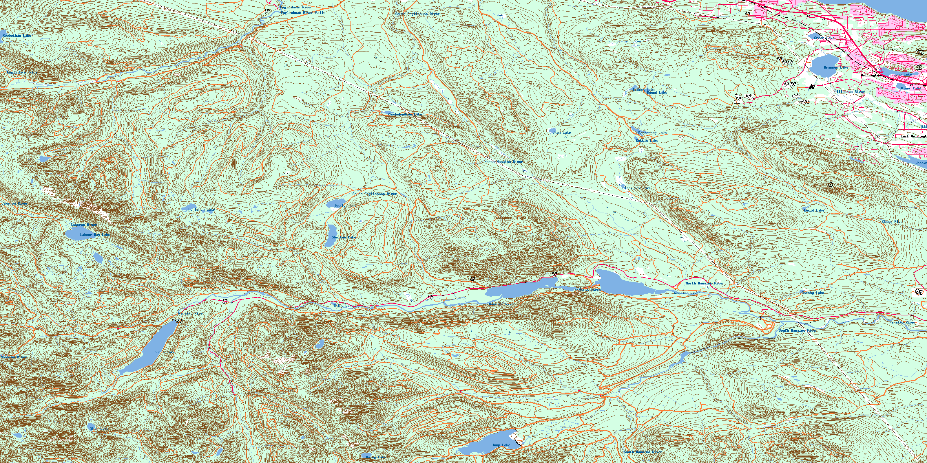
nanaimo lake topographic. the land of a 1000 lakes. how many have u seen? i guess i cant upload the full pic here. sorry! this is where i got it from.
http://www.canmaps.com/topomaps/nts50/toporama/images/092f01.gif pic!
http://www.canmaps.com/topo/nts50/topomap/092f01.htm
so we all know where we going. i dont like this one. but its decent size to draw on.

That's a pretty huge map!
I just bought a new Garmin unit a couple weeks ago. It's so much better than my old handheld. Luckily my old topo maps work on it so now I've got a proper 5" display with topo for all the west coast. I uploaded all my Google Earth maps/routes too so when I'm out driving I can see the new places I want to check out.
so how do u mark landmarks and whats at where u r? notes and letters? can u draw on ur maps? the woods change drastically. some of the things on my map. 2wd rd. 4x4 stock. crawl and mud. i use different colour pens. i also mark things like bridge out. beaver dam. dips. out of commision. short cuts n cut throughs. places of interest. view spots. i write it like a parks map. i know where all the roads are by glancing at a map of the island when i was 10. lol. but do u know the trails of all the 1910 railway lines.they r still walkable. some driveable. where did they get washed out. where do you cross the river. all this changes. so unless iur into typing notes and spending the time to document it all and read it all back. compared to glancing at symbols on a map u drew. maps have been around along time for a reason. im glad we have the gps. its great. but its only a tool like a compass. map making is a skill and a trade. its something thats taught to every boy scout and beaver. its a skill that will save u so much time and trouble. anybody can pass on co ordinates. but that years washouts and road closures would be nice to know. the old maps also tell u where u might be able to get in. any old jeep wrangler is a tree remover n trailblazer. whats all along the way is half the fun. if i can keep maps on my bike then theres plenty of room in a truck. dont most vehicles have to come with a map compartment. i guess in canada we call it the glove box. cars are cold here in winter i guess. maps are instantaneous if open. but whats the shot gunner going to do? lol
try to google earth the trails in extension and try to tell people where and how to get in. theres got to be 20 roads in 10sq miles that all crisscross.