
This info is for iphone users but there may be apps like this for others like androids etc...
I see many people using expensive GPS units in their rigs mainly for creating tracks of where they went.
I have purchased an app for my iphone ($14.99) called Navionics and its main use is for marine and lake charts (bathymetric depths) for all of Canada and USA. The bonus of this app is that you can go into settings and overlay google earth satellite air photos that are very current (topographic overlays as well). You can create a track that you can add waypoints or take photos of what you find and the photos are geo-referenced to where you took them. If you happen to be going fishing at a lake you now have some depth maps as a bonus
This GPS does not require you to be in cell range and works quite well in heavy cover (I use it in my pocket while timber hunting) and maintains very good accuracy.
When you are done just stop and save the track.
The best part that I find very useful is that you can just email the track to yourself or a friend and they will receive a KML file that can be opened in google earth showing your track and all your photos/waypoints. If you were to have a break down or injury and happened to have cell service you could send an exact location that someone could see on their computer. (I have a folder on computer full of tracks I can pull up anytime).
It is extremely user friendly and best of all cheap.
Any iphone GPS app will be heavy on the phones battery but just go to any of the dollar staore and they have car chargers for $2.
I just plug mine in and stick it on the dash.
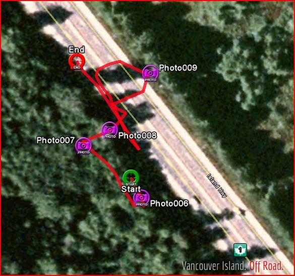
Here is an example of one I did for my job. If this was actually google earth these photos would open up and show you the picture. If you want to save the picture to home computer just email them to yourself as well....there may be a better way just havent found it yet.
I posted this on Island 4x4 but thought it should go here too.
Good info. I haven't tried Navionics but I've used a few other iphone gps apps. Saving as kml is certainly a big bonus.
As an aside, you can upload kml files to this site when you create a new post and it will embed an interactive Google map with your waypoints/tracks!
Do you just upload the KML to the post as an attachment??
When you're adding the post, there's a little link labelled 'GPS tracks' under the image attachment. You can see an example of a post with a kml track at http://www.vioffroad.com/forum/routes-destinations/sherk-lake
Thats a great idea. Will try that sometime.
Another one for the android users is Backcountry Navigator. $9.99 and you can download maps from around the world. Does pretty much the same as Navonics. I purchased it a month ago downloaded it on my 10" Samsung Tablet, purchased a Ram mount for $80 and I have a great GPS for under $100 and I can actually see it. Works better than any conventional GPS units that I have used.
http://www.backcountrynavigator.com/
So you could go deep into the logging roads and it will still track you?
Yes. It will track your movements. You don't need cell coverage for it to work.
Ya I use Backcountry Navigator pro, and both apps can be used without cell service.