
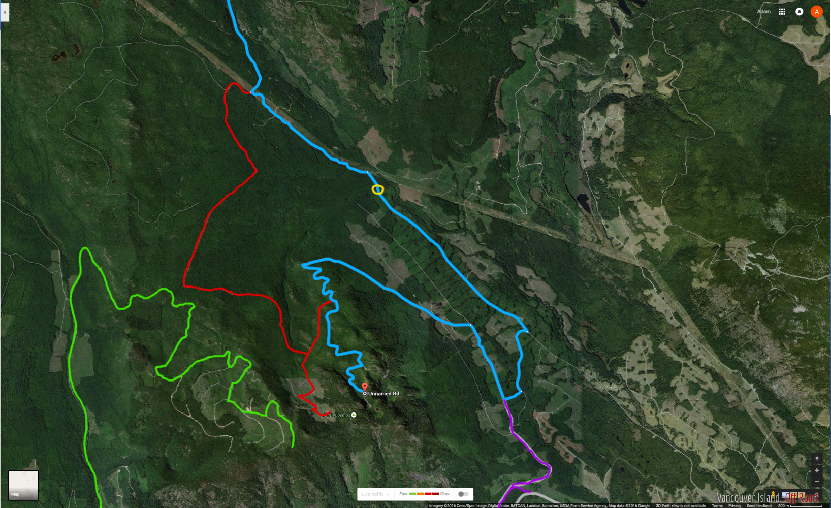
First time posting, only been offroading for a few months so go easy on me for my stupid decisions (they are plentiful), as well my information is based totally on what I have seen and I could be wrong on anything. Also Im hoping I put this in the right section.Anyways, has anyone got up to the top of Mount DeCosmos? I'll attach an image of a map so this explanation makes sense. I did a bit of research and I found that it is relatively undocumented online, but Google maps claimed it was possible (blue line) so I assumed it would be an easy ride in. No challenge at all at least until the power lines, then after that it would probably be relatively easy all the way up. But at the yellow circle there was an impassable river, it looked like there was a bridge at some point, but it had collapsed and/or demolished. Next we attempted the red line, but took a wrong turn, got stuck in the mud, and had to back down about half a kilometre of trail that we shouldnt have gone up and that were barely wide enough to fit through. So we didn't even get 100m up that trail (it was pretty tight), then we headed home as the rain was only getting worse and it was getting dark. I havent tried the green route yet, but that may or may not work, I cant see any trails that will get any closer than a kilometre (which is close, but I'm stubborn). The purple route has an impassable gate and the rest is dug up.
By the way, I have a non-lifted full size, and although I am used to taking a brute force approach to tight trails, as well as pinstripes, there are limits to where I can get through. The area was pretty neat, we did a few little trails on the way to the mountain and I got a few cool pictures, I'll be heading back this weekend and making another attempt. I have a few friends coming out from a much flatter part of the world and I thought this would be a fun adventure for them, but I have to actually figure out how to get up myself first.
I think thats enough words to start a productive conversation about something, thanks for any insight anyone can give.
Here's a couple pictures because why not
welcome to the forum! nice dude that looks like a sweet spot to check out, yea just looking at that green trail, if it doesnt seem like theres an opening in trees to get to the top its (usually, from my experience) because there isnt, the log big sections but dont necessarily connect two sections together all the time. Do you think the red trail would go all the way up if you kept going? and for rivers, yea especially right now with so much rain and warmer weather, the rivers are super high! keep us posted if you get to the top :) nice pics! I know the limitations of bigger trucks haha, ( well, longer in my case) its not always easy, but just makes an extra challenge!
You wont make the blue or the red in that vehicle as those routes get rougher than what your truck can do and will likely lead to you having a real bad day (i.e. rescue)......
The green route is standard logging road (C branch), there may be a locked gate about 3/4 ways up in the clear cut at top.....sometimes its locked and sometimes not.
An interesting spot on the green route is an old hard rock gold mine......where the green line runs north and then almost does a 180 turn, come back from that to the junction that you dont have marked that heads northwest, then come back from that maybe 100-200m and there will be an old road that heads up to the right (basically between the green lines is a ravine if you zoom in) at the end of this road is a small tight landing (may be tight to turn that truck around at) over the edge of landing is a rope, climb down and look upstream to the entrance to Dead Horse Mine.
Havent been in it myself.....had my daughter with me when I got there and would be too difficult/dangerous for her to try, but have seen pictures.
A picture taken from inside of the mine for you guys.
thats sick! thanks sean!
Thanks. It`s an area that I try to explore at least once a year. It`s about a 100km return trip plus wheeling from Nanaimo.There`s an old abandoned rec site on Shelton L a couple miles away from Deadhorse to camp at, some good "quad" trails and there`s more then just the one mine in the area. If they would just open the gate at the end of second lake you can access a lot more from there.
I was thinking of dragging GoGo and an inflatable kayak to the lake this year, I`m getting to old for the ground.
I dont know the area that well, me and Fatty made our way up past highway mans trail and over to the gold mine...stopped in at Shelton lake campsite which was really cool and secluded. Over to Moriarty and then returned...pretty good day.
Any of you fellas care to share the Shelton lake campsite location or gps file over pm?
ya that looks like a sweet spot at shelton lake. how hard is it to get in?
You can get to it from the east by coming in through the blackjack ridge and or the hydrolines but there is a trail I call Pickle you would have to navigate that isn`t full size friendly. The picture I posted earlier with my jeep in it is on part of that trail. Highwayman trail also comes into it but it`s also not fullsize or stocker friendly.
You can get to it legally and in a full size or near stocker if you enter at the gate in Nanoose then make your way up to Rhododendron lake. Don`t go in the Rhodo Hole at the lake as asshats have put some sharp things in it and the last time I was in it I had some tire repair to do after winching myself out. On the FSR to the south west of the lake there`s a "somewhat overgrown" old spur that eventually comes out between Panther lake and Deadhorse. It`s a very long one that sees little use and is missing some bridges. I haven`t opened it up this year and very few people use it so bring a saw as there is a lot of blowdown out there this year. Look in the map book you`ll see it. It`s a whole day of wheeling if you plan on leaving through the manned gate again in Nanoose, so get an early start.
I included a picture of the spur at the Rhodo end looking southwards.
Once your at Shelton the BC forestry rec site signs are still up. If you wander around a little there`s water front and wooded sites covered in moss, some with picnic tables.
So I went up again against Fatty's advice to see these trails that he said I couldn't manage myself. He was correct, I could not manage them. The road was tight but not that bad, until there is one part that was cut out by a stream making it quite rough. 6" of lift and a winch and I would try it, but there is no way I could make it in the trucks current form. (The first and second pictures are most of the trail, the third is where we had to stop). We also revisited the path and river that stopped us last time, turns out there is a trail that leads down to the river (not sure how I missed it last time), a little rough for me, but I might try once I get the truck leveled and some new (bigger) tires. How bad is the actual trail up the mountain? The one with the switchbacks on the north face. It looks pretty clear if I was coming from the south. After we failed to accomplish our goal we went up about a kilometre north-east and explored around there for a bit, It was a really neat area, definitely worth going back at some point. I marked what I think is the next logical attempt on a map(from the south this time). I know that there is a gate blocking this road, but I remember one of my first times out with this truck that I found a short trail right before that road that went down to that small river, I think it may be a way to cross it. Although its been months since Ive been there. I think I'll try that one next weekend, I may also check out Deadhorse mine if I can.
sounds like an adventure! keep trying, keep us posted :)
I was up Branch C last weekend, just when I started getting amped to explore I noticed machines working on the hill beside Shelton & Healy. Was late in the afternoon and I didn't feel like getting stuck behind the gate at Second lake when they called it quits for the day.
I was so close it is painful. I got to around 745m of elevation up the north-eastern face (the blue trail on my first map), where the first switchback is. One fairly steep section was pretty washed out and took us about 45 minutes to go about 100 metres, lots of crawling and moving rocks around to get through, (dropped a rock on my hand, thought I broke a finger, probably didnt though), it is the most technical section of trail I have ever successfully passed. After we got past it it was relatively smooth until about 600-650 metres where we encountered snow. My truck is totally incompetent when it comes to snow, which can be fun in a flat parking lot, but not on a 15-20% grade up a dirt road with rocks on one side and a shear drop of death on the other. The roads weren't rough at all, but they were just steep enough that I kept sliding back down them. Had to turn back as I didnt bring chains (nor do I own any). I may attempt it again tomorrow should I find/fashion chains. If not, next weekend.
Oh yeah and I cracked the bumper (second picture), and submerged the truck in enough water to come halfway up the hood, very suprised that it kept going with no issues other than it's making a strange howling noise now. Ive blown 3 out of 4 shocks, a ball joint is broken, and the left front wheel bearing was shot (fixed that on monday though). There was a ratchet strap stuck in a brake caliper, and I keep finding sticks and stuff stuck in various parts of the engine and suspension. So yeah, its been an interesting week, we've personified the truck by giving it the name Deathtrap due to our belief that only a sentient being could have enough hatred in it to try to kill/punish me as much as this vehicle does (both physically and financially). In case you are wondering who I keep referring to as "we", that is usually in reference to myself and my usual co-driver Dima, he would be the one in the blue jacket making snow angels at our point of failure.
Wow you are beating that truck hard! You blew 3 shocks lol?! Crazy, give it a bit of time to melt I'm sure you'll be able to make it :)
So how did you get to those switchbacks? Was it the blue trail in first map or second map? I thought blue trail in first map had a impassable river crossing
You have a great sense of adventure.
You'll make it. Keep trying.
Attempted to find deadhorse last weekend, going to attempt again soon. If anyone has coordinates to the mine please post!!
Seems like a fun adventure! Be careful though! Being stuck or broken down for a night in the snow would not be much fun. I keep some tools and some basic emergency gear in my truck just in case. Never know when the little washout you drove through becomes much bigger when you head back through on your way home.
But a rec site, secluded lake, mountaintop views and mines to explore sounds like my kind of trip. I think I'll make some trips to explore the Nanaimo area this spring or summer
49.117748 - 124.271548
Thank you!
Found deadhorse, What a great place. little hard to get down into the creek though. East sooke mines are also very captivating as well
That's awesome that you found it, and definitely not a place you want to take your grandparents.
Hi there! I went up DeCosmos last summer, when the gates were open, via your green line. I parked close to the end of it and hiked to both summits. The true summit is not driveable, but you can park close to the west summit and bushwhack across the saddle. There is a flagged route (more of a suggestion than a trail per se) that I guess must occasionally be used to service the radio towers (there is a helipad on the east summit).
Anyway, the summit area is very rocky and very overgrown. It's tough to hike up there, let alone drive.
Hello Trail Seekers!
Just joined the forum, new to the island, and unfamiliar with the RULES of the back roads. As full sized vehicles, off road passenger vehicles are allowed are OHVs a legal entity once the vehicle trail ends and narrows to a trail in the woods. Attempting to understand if I tow my quad to the end point if the trails prohibit OHVs?
Thanks for sharing your adventures.