So today I decided to take my girlfriend Stacey out and try the Bear Creek Reservoir run from Jordon River for the first time since it's no longer 2WD accessible.
I have been to it before years ago when you could basically go all the way in your Honda Civic if you took it easy. In a way, it's good that only 4 wheelers can get back there now because too may people were going in and camping there and shooting the hell out of everything and leaving garbage and scrap strewn around everywhere.
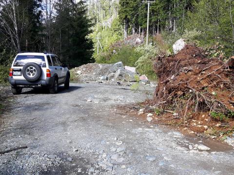
A short section of the road in that is about a km long is a bit of a mess now due to a slide, a washout and the resulting obstacles now keeping 2WD traffic out. People have worked passes in for ATV's but it is a bit difficult to get through the narrow passes completely unscathed unless you have a short wheelbase 4x4 with some decent clearance. I went through slow in low range and made it though everything and back again without anything scraping or even having to skirt the cliff edge. There is a series of three slide/washout passes and it definitely isn't pretty to look at but it should be passable for anyone with a decent 4x4, a bit of patience and some experience offroading. I passed a 4-door Jeep Wrangler coming back and a Toyota Tacoma as well as some ATV's and motorbikes before getting there myself. Just don't try this in your stock Rav4 or CRV if you don't like crunchy sounds under you. The first pass is the 2nd worst one, so if you don't chicken out there, know that there is one slightly more sketchy one ahead of you with a big boulder in the middle of the road just before you are in the clear, and remember, you have to go back the way you came in unless you would rather try to cross the creek at the reservoir and getting on to Butler Main but I have no idea what ways out there may still exist without gates.
I'm going to try to upload some photos and videos and a tracklog map of the route up. For now, this is all technically open but keep in mind there are now private lots starting to get carved out of the landscape on the lower section of Forebay Road and stay out of the sections marked private property. My original plan here was actually to do some trail blazing up on the loop trail on the East branch but I got turned back by snow again half way through on the north side of the hill up at 625m elevation. I'll give it another couple of weeks to thaw completely on the shady side and see if I can't get all the way around the loop. If so I will post that trail some time in the future, which should be a fun one too. Lot's of trees are down and lots of weeds growing in on some places so it may take a couple of trips to hack my way through it all. Enjoy the trail map and photos. I have a few video clips too, I guess I will need to upload those and link to share here...
Cheers!
O4AR


Here's the WikiLoc Trail link.
https://www.wikiloc.com/wikiloc/view.do?id=17614992
Here's a video walk-thru of the first pass on the way to Bear Creek Reservoir.
https://www.youtube.com/watch?v=143TknMrJmg
Getting through the first pass.
https://www.youtube.com/watch?v=vfgCmNXsqrE
Getting through an easy pass.
https://www.youtube.com/watch?v=tfDVRvP_krs
Here's the gnarliest bit going through the passes.
https://www.youtube.com/watch?v=yQyJ6QV3070
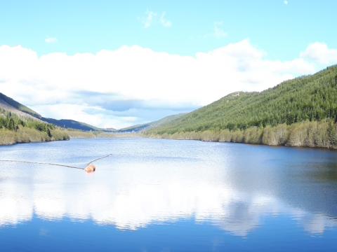
Here's why it's worth going through the ugly stuff.
https://youtu.be/PMun1QhhLAw
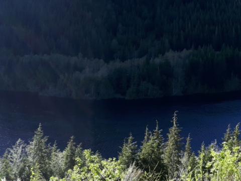
When you get there, it's all worth it.
https://youtu.be/OdFzDsSnuT8
thank you! been waiting to try that road again.
Here's a bonus clip of the second pass I forgot to upload earlier.
I decided to run one wheel in the ditch and one on the cliffside bank which is a tippy feeling line straight through instead of having to try and balance it in the uneven track, but at least you don't have to look down.
https://youtu.be/LA33hJ36lS4
Looks like you guys had a good time up there! Looks pretty passable for any 4wd vehicle if you don't mind rubbing the bushes or rocks a wee bit. Beautiful country up there but when I used go explore the area it was blanketed with garbage and junk. What was it like now? I would be happy to be part of any cleanup runs anybody might organize. I can fit a lot of junk in the 4runner, and it helps to make us all look good and keeps our island beautiful
^^^^^^^^this x1000
last time i went up to check the snow level and pulled over for a piss, and these two trucks coming up behind us. thought it was a good sign, other people out here. waved. then i saw the refrigerator in the back of his raptor. if you can afford a raptor you can afford a dump run. I shoulda got the plates, i would snitch so hard on that shit. I try to take a bit of trash with me each time i go anywhere. usually it isnt so bad, but i havent been all the way to the reservoir you're talkin bout yet. if there is a cleanup run, i'm 100% in. that sorta good will goes a long way.
I was thinking exactly the same thing when I was there too. The Reservoir area could use a bit of surface cleanup but it actually looks half decent now since a lot of the bigger junk I remember being there, isn't anymore. A couple 20l pails would collect most of the junk I saw there. The Forebay area is a total shitshow free-for-all right now though. There's still a lot of shotgun casings, old rusty nails and whatnot from scrap people were burning, some corroded metal and a few appliances. At the end of almost every dead end haulway there is a small unique dump of junk.
looking at the footage i think i could make it in there on my rig, my next free weekend day is Sunday the 28. Let me know if anyone is headed into clean up a little.
It's really not that bad to get in.
Based on a couple of the stories I've heard you'd think it was like storming the beach at Normandy or something.
I was not sketched out at all but I did add a bit of dramatic flair for sake of video though. It was definitely worse looking the last time I was up there so people have been working it and smoothing it out a bit. A Toyota Tacoma was coming back out just as I got past all the uglies.
There is only one place on the passes where you may scrape a bit on rocks if you're too low or take a crappy line over the boulders but there was also this one nasty sinkhole I passed near the home stretch that was easy to miss that could wreck your whole front end. The mouth was about a foot across but wide and deep enough inside to swallow the next fool to get too close. The East Branch loop trail is a total bushwack right now so I am determined to tame that one enough to find this camp site my uncle told me about up there so there's a good chance if I'm free that weekend and there's a couple people going up I'll definitely want to go along.
I saw a couple of sink holes like that on Gordon River main 2 weeks ago. Fortunately someone marked them with a few logs and tons of flagging. The deepest was 16" in diameter and over 3' deep!
so i couldnt resist, and made a run up there tonight after work. the technical parts, you just gotta him them right, look WAYYYY worse than they actually are. made it to the damn. next time i'm determined to check out that water crossing, and if possible, head to leechtown by vehicle.
a heads up for anyone attempting it, it took us about an hour to get from the beginning of forebay road, to the damn at Diversion, including airing down, and stopping to scope out lines on the technical parts. also, the maps dont really do it justice. the size of those lakes man. they're huge. give yourself time.
Can ya make a good day trip out of it or just a few hour Hours?
From ladysmith I think you could make an awesome day of it using old Renfrew rd from Shawnigan, then south on Jordan main to get to the reservoirs. Haven't made the gap between bear creek reservoir and old Renfrew myself though, I wonder if there are any gates or major washout?
I believe the Weeks Lake pass is still gated and a no-go, otherwise that would be a good way to get to the Butler Mn side of it from Shawnigan.
The gate to weeks lake was closed when we last checked it out, mid-march I think it was
So, just a couple of updates for this thread.
Don't bother trying to get on to Butler Main from the Bear Creek Reservoir dike by crossing over the creek unless you're running serious meat, lifted and locked.
There is an "easier" way a bit further back but it's also not pretty, and even if you go through you are still trapped inside the gated area unless you have a tracked unimog, foldable bridge or know of other trails that can get you in to an open block. There's still lots of activity going on back there on weekdays so just stay out.
Yesterday we ran in to some other wheelers going to Tugwell Lake so I guess that confirms you can still get there if you have the right rig for it or don't mind grinding a couple miles of washed out trail. I definitely wouldn't go it alone without at least one other well equipped vehicle and a winch but in our meanderings we did find a really sweet camping spot right on a creek that is pretty stock friendly so I'll definitely be taking advantage of that some time this summer...
Also want to say thanks again to Zukiman for a great day out on the trails and for showing us some awesome places we hadn't ventured to before.
I believe you also answered a nagging mystery as to the whereabouts of something my uncle told me about over a decade ago but I could never find. ;-)
Looking forward to another run some time...
yeah, on that. the western one was doable in my rig. stock xterra with 32s and a 2" Body lift. i declined to pass though on the muddy section cause my tires are worn out BFGs. a guy in a 4runner came up it no problem, he was on 33s or 35s. the one above the water crossing... sucked. a lot. but i made it up. But I also wouldnt do it again. what a fucking ordeal. I sheared a leaf spring on butler main somewhere and tried to find another way out. I saw a lot of gates. eventually went back through the river in the sunlight. FYI, there are enormous tank traps all over the other entrances and exits, covering what I assume were bypasses.
Yeah, noticed there is a new quadruple tank trap on Old Renfrew Rd.
Not your usual backhoe trench and dirt pile either. These were fucking war!
there was a way at the end of your line its been dug out but was doable last year in my rig had to winch though the last part. there was another route up passable in my rig just back from that spot as well both pop you out on butler main then you can go through jordan main and come past weeks and out renfrew main into shawnigan providing the gate at 8.5 km and 6km are open.
Yeah we did go back and we poked around a bit more and ended up on Butler.
The Old Renfrew Road gate is locked and the upper road and bypass was quadruple double super trenched trapped beyond all recognition.
I did have this old track/route saved in my GPS that said "A Rd Bypass Rte" and I believe at one time it was supposed to get you around a particular gate but I didn't bother trying it because even if the route was still passable the exit would have made a longer drive home than going back the way we came.
I poked my head in there this weekend. Passed a jeep on the way out that didn't try the washouts, and a full size that was parked before the first wash.
I will say they look way worse then they actually are, my stock Tacoma scrapped the exhaust a little on a rock passing the first wash, (it's stated as the 2 worst one, but I think the others were easier!)
The 2 and 3'd were only off camber and I'm glad they roll you away from the cliff edge!
Walked out on a couple of the dams as well while we were back there, but unfortunately due to time constraints we didn't make it past the second resi. But I will be going back and pokeing around a bit!
There are a few ways from Bear creek to get up onto Butler main. from there, you can get up to tugwell lake or back to boyds pit. or over to boneyard.
Ok my girlfriend loves bones... Are there actually bones at Boneyard, or is it just one of those odd names that was given out?
If i remember correctly back to my youthful days of partying up in boneyard, the name likely came from a collection of broken down equipment and scrap that was piled up there (but isnt anymore).
Well, that does make sense. Was hoping for a fossle bed, but old machinery makes sense!
New to the site, going to explore the Jordan River Area in a couple weeks. Can you get to West Leech Falls from Bear Creek? Or is there a closed gate at the west side of Bear Creek Res?
you cant get to leech falls from butler main. it is gated.
Went out today up to bear creek res through butler main and there were no gates up until you get to the first gate of diversion dam. But we found a sweet abandoned cabin... kinda creepy. Pretty squeaky clean up there and didn’t see anyone along the way
How hard is the route? I worked up there when I was in high school and I'd like to go back and see the place.